The Iberg was a coral reef south of the equator during the Devonian period, famous for its formation and the historic iron ore mining. Today it is a protected FFH area, rich in caves, of which only the Iberg dripstone cave is publicly accessible, with stands of lime beech and rare yews.
The Iberg - A Coral Reef
Short facts
- start: Cave Experience Center in Bad Grund
- destination: Cave Experience Center in Bad Grund
- medium
- 5,01 km
- 1 hour 35 minutes
- 564 m
- 370 m
- Loop tour
best season
Tour waypoints
HöhlenErlebnisZentrum Iberger Tropfsteinhöhle
130 Iberger Albertturm
Waldgasthaus Iberger Albertturm
Märchental
Tour-Dashboard
Pavings
- Asphalt Coating (22%)
- Hiking Trail (62%)
- Crushed Rock (13%)
- Street (3%)
Weather
General information
It is recommended to walk the route clockwise, so the opportunities to stop for food come when you have worked up a good appetite, that is, at the peak and at the end of the route. You walk this not too long circular route almost continuously through forest.
On the western side of the Harz, the karst hiking trail begins at and around the Cave Experience Center at the Iberg near Bad Grund. The building exhibits the finds and evidence as well as a replica of the Lichtenstein Cave; thus, the real Lichtenstein Cave, located between Dorste and Förste and once the grave of a Bronze Age extended family, is linked with the exhibition to this significant excavation and cave archaeology in the Cave Experience Center.
The Iberg is the mother of the mining town; iron ore and later also polymetallic ore have been mined here for thousands of years until 1885. The 385-million-year-old coral reef made of Devonian limestone is heavily karstified and houses dozens of caves. Today the Iberg is protected as an FFH area, the near-natural forest with beech and noble deciduous woods as well as the rare yew is left to develop naturally. At the adjacent Winterberg, part of the reef, high-quality limestone has been quarried since 1938 in the largest quarry in Lower Saxony, best viewed from the viewpoint on the summit of the Iberg.
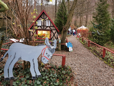
First, you go below the car park into the Devil’s Valley, where soon to the left is the fairy-tale ground for children. On the right is the entrance to the iron ore tunnel. Iron ore was mined here until 1885 and smelted on the site in front. Today the extensive mining system, which reaches down to the karst groundwater in the Iberg—which is also the drinking water for Bad Grund—contains a healing tunnel used for therapy of certain lung diseases. There is also a memorial stone for a victim of the death marches in April 1945.
The path leads west below the B 242 road; on the left lies the Iberg settlement, built in 1938 mostly to accommodate South Tyrolean workers for the limestone quarry established at the same time. We now come to the Hübichenstein, a double rock needle made of reef limestone, already climbed by J. W. von Goethe on August 12, 1784.
The climb is worthwhile with a beautiful view over Bad Grund and the Iberg. Deeper in the rock are old iron ore mines. Here Hübich, king of a legendary dwarf people, is said to have lived (or does he still live?). The continuous karst hiking trail would continue via the “Canada Path” through the World Forest, then past the former Grund ore mine and to the western edge of the Harz with magnificent panoramic views over southern Lower Saxony.
To the right and across the federal road (caution!), the route goes up the Hippelweg, a cut between Winterberg (left, quarry) and the Iberg. The cut is the trace of a probably Upper Carboniferous fault surface where the Winterberg, with a limestone thickness of about 600 meters as the upper quarter of the reef, was pushed downward to the west, so today the reef appears doubled. At the upper end of the Hippelweg, the route turns horizontal onto Maibohmshöhe. Soon there are deep pits on the right side of the path, evidence of historic iron ore mining, simultaneously transformed natural caves. Caution: danger of falling; do not leave the path! Now the route goes up to the Iberg high plateau, passing on the left the formerly so-called glacial pots, karst hollow shapes with mining influence, but no glaciers ever were here.
At the Iberg Albert Tower, there are refreshment options and a panoramic view from the tower. Shortly thereafter, information boards explain the archaeological research of the early history of mining on the Iberg. A viewpoint with info panels extends the view to the largest quarry in Lower Saxony, whose mining areas now extend into the Iberg itself.
Several caves, some with huge dripstone formations, were found during quarrying. Across the Iberg high plateau, it gently descends on an old forest road to the Bismarck cliff. From here, the view wanders south over the steep, beech-forested slope of the Iberg. The forest in state ownership has been withdrawn from management for several years and natural development has been scientifically monitored since then. Except for traffic safety measures, no work is allowed.
During the further descent, the path bends at an autochthonous occurrence of yews, a tree species typical for this substrate and climate but now rare.
It remains unclear whether the name "I"berg is derived from yew (Ibe) or iron (Isen).
It is recommended to walk the route clockwise, so the opportunities to stop for food appear once you have worked up a good appetite.
Cave Experience Center, An der Tropfsteinhöhle 1, 37539 Bad Grund (Harz)
Bus stop "Cave Experience Center"


