© Klaus Leidorf

The Green Belt in the Harz

from death strip to life line

The “Iron Curtain” separated men and nature in Europe for almost 40 years. Lethal to humans, it was however a blessing for nature as endangered animals and plants found an undisturbed home in the shadow of the border.

Today, the former border acts as a “Green Belt” across Europe - a treasure trove of bio-diversity.

Especially in the Harz the painful reality of the inner German border was present all the time. The Brocken an impressive and highly visible symbol of the Harz could only be seen from afar by people from both East and West Germany, as it was located in the military zone and was out of bounds.

Today in the Harz it has a new face; the “Green Belt”, where natural beauty nestles to cultural treasures along the former death strip, providing a valuable habitat for endangered animals and plants. Adventurous trips go hand in hand with contemplative moments while you enjoy wandering through pure wilderness in the footsteps of German history.

Find out more about the Green Belt in Germany or the Harz Border. The art of the Green Belt and further interesting things are worth checking out too. If you do not want to explore on foot, then why not use the cycle route along the Green Belt.
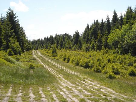
Harz Border Trail

Kolonnenweg am Grünen Band im Harz© HTV

The former inner German border stretches 100 kilometers across the Harz landscape and traces the history of a once divided Germany. This former border patrol path crosses the Harz on a varied and sometimes hard hiking route.

The Harz Border Trail is part of the Green Belt that runs across Germany and once divided Europe. It runs along secretive boundary paths or former "patrol ways." This former inner German border combines in a unique way the nature, culture and history of the Harz Mountains. It crosses the mountains on a diverse and sometimes challenging hiking trail between the border watch tower at Rhoden (Osterwieck) in the north and the border museum in Tettenborn (Bad Sachsa) in the south.
Through the valley of the Ecker, following the small river that once was a border river, the trail winds its way along to the Ecker Dam which was also divided into two parts. The trail continues winding its way up to the Brocken, past the 'Dreieckiger Pfahl'(Triangular Post), a historical boundary stone. The trail goes beneath the Wurmberg to the memorial to the opening of the border, between Braunlage and Elend. Remnants of the division of Germany are stored in the open-air border museum near Sorge. The “ring of memory” and the Drei-Länder-Stein (boundary stone) by Benneckenstein are contemporary border markers on the way to the Walkenried Monastery. At the monastery you can get a fascinating insight into the importance of Cistercian monks and how they helped in the development of the region.
The Harz club has provided new signs posts along the trail. Information boards teach about protecting habitats and historical sites along the way. For those who want to know more, guided tours with specially trained staff are offered.  Specialized tour operators can organize hiking without luggage through various stages along the Harz border trail.


The Green Belt in Germany and Europe

An idea is born
From the Arctic Ocean in the North of Scandinavia to the Black Sea in the Bulgarian South the border formed an insurmountable barrier - politically and geographically. In Germany the most brutal side showed the iron curtain: walls, mines and barbed wire divided the country into East and West that tore families and friends apart for decades. At least 900 people were killed while trying to cross the border. Then 1989 the borders opened. Immediately it was clear that from the protection of the border fortifications a precious piece of wilderness had grown a lifeline for flora and fauna. The conservationists reacted quickly and sat down to find a way how to preserve this magnificent natural heritage. They came up with the idea of the "Green belt." A vision was born and one of Europe's largest nature conservation projects began.

Pearl Necklace
Today, the green belt stretches across 23 European countries and over 12,500 kilometers; at times it can be 50 meters wide and at other times many kilometers. Marshes, meadows, forests, rivers as well as lakes are strung together like pearls on a necklace. Scientists talk wildly about one of the longest "biotopes protected areas" of the world. Here we see wildcat with their offspring hidden in caves, cranes trumpeting their song without interruption and otters playing in the water. Large mammals such as wolves, bear and lynx use the green belt as a trail to spread steadily across Europe.

Imminent Danger
In Germany the Green Belt reaches from the Baltic to the Saxon Vogtland, almost 1,400 kilometers long, 177 square kilometers in size and 109 different habitats strong. However it is not all sunshine and roses on the Green Belt. It is being threatened by intensive agriculture and forestry, new settlements, ICE routes, new roads and more. In some areas the Green Belt is only a few meters wide or even disappeared.  There is an active campaign to prevent further lost and to ensure that the colorful mosaic of different habitats is maintained.

It appears that you are using Microsoft Internet Explorer as your web browser to access our site.

For practical and security reasons, we recommend that you use a current web browser such as Firefox, Chrome, Safari, Opera, or Edge. Internet Explorer does not always display the complete content of our website and does not offer all the necessary functions.