© Harz: Magische Gebirgswelt

Routes to the Brocken - from Ehrenfriedhof

Short facts

  • start: Ehrenfriedhof on the B4 between Torfhaus and Oderbrück
  • destination: Brocken
  • medium
  • 7,10 km
  • 2 hours 2 minutes
  • 1141 m
  • 826 m

best season

Good 7 kilometer long hike from the Ehrenfriedhof via the Kaiserweg, Kolonnenweg and Goetheweg to the Brocken

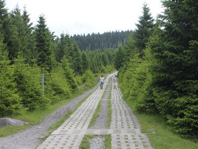
On the shortest route to the highest elevation of the Harz - the Brocken. The signposted hiking trail starts at the "Ehrenfriedhof" parking lot on the B4 between Torfhaus and Oderbrück and leads relatively gently uphill past the Ehrenfriedhof. Following the signs, you reach the Dreieckiger Pfahl, the border between Lower Saxony and Saxony-Anhalt. On the Kolonnenweg, the path continues quite steeply on a paved surface, which is also suitable for inexperienced hikers. When you reach the Brockenbahn tracks, the hike follows the Goetheweg along the tracks up to Brockenstraße. The entire hiking trail is surrounded by beautiful nature and great views over the Harz.

Tour waypoints

168 Dreieckiger Pfahl

136 Eckersprung

The "Green Belt" – Lifeline along the former border

Stichwortfahnen am Goethebahnhof

The Brocken Railway

Peat digging of the Goethe Moor

The Brocken old growth forest

A little house in the clouds

Brockenhotel

9 Brockenhaus

Malerblicke im Harz - 15. Brockenhaus

Der Brocken - das Höchste im Norden

Tour-Dashboard

Pavings

  • Crushed Rock (81%)
  • Street (18%)
  • Path (2%)

Weather

General information

Next steps
Download GPX Tour-Portal

It appears that you are using Microsoft Internet Explorer as your web browser to access our site.

For practical and security reasons, we recommend that you use a current web browser such as Firefox, Chrome, Safari, Opera, or Edge. Internet Explorer does not always display the complete content of our website and does not offer all the necessary functions.